Pakistan Launches EO-3 Satellite Successfully from China
Pakistan Launches EO-3 Satellite — And It Is a Bigger Deal Than Most People Realise
Space programs do not always get the attention they deserve in countries where the daily news cycle is dominated by politics, economics, and security. But what happened recently at the Taiyuan Satellite Launch Center in China deserves to be recognised for what it actually is — a genuinely significant milestone in Pakistan's technological history.
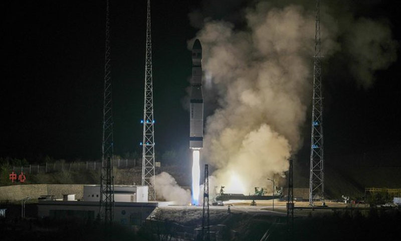
SUPARCO, Pakistan's national space agency, successfully launched the EO-3 satellite — an indigenously developed Electro-Optical Earth observation satellite that represents years of scientific work, engineering effort, and institutional commitment to building a real, functioning space capability for the country. The launch was successful. The satellite is in orbit. And Pakistan now has something it has been working toward for a long time.
Prime Minister Shehbaz Sharif publicly praised the scientists and engineers at SUPARCO whose work made this possible, and also acknowledged China's continued partnership in supporting Pakistan's space program. Both of those acknowledgments are appropriate — this achievement did not happen without the people who built it, and it did not happen without a strategic relationship that made the launch infrastructure available.
But beyond the official statements and the ceremony of a successful launch, it is worth taking a serious look at what EO-3 actually is, what it can do, why it matters for Pakistan's development, and what it says about where the country is headed in terms of its technological ambitions.
What Is EO-3 and What Makes It Different
EO-3 stands for Electro-Optical Satellite number three in SUPARCO's Earth observation series. The electro-optical designation tells you something important about what this satellite does — it captures images of the Earth's surface using optical sensors, producing high-resolution visual data that can be used for a wide range of analytical and planning purposes.
High-resolution satellite imagery is not a novelty in today's world. Commercial satellite imagery is available from various providers, and countries with well-developed space programs have been using Earth observation data for decades. But there is a fundamental difference between buying imagery from an external provider and owning the satellite that produces it.
When you own the satellite, you control the tasking — meaning you decide what it looks at, when it looks at it, and at what level of detail. You are not dependent on a commercial provider's availability, pricing, or willingness to share certain imagery. You are not subject to restrictions that foreign providers might impose on data about sensitive areas of your own territory. You have an independent, sovereign capability that serves your national interests on your own schedule.
That distinction — between dependence on external providers and genuine indigenous capability — is at the heart of why this launch matters. EO-3 is described as indigenously developed, which means Pakistani scientists and engineers played a central role in designing and building it. That is a very different thing from simply purchasing a satellite from another country and putting your name on it. It represents the development of real technical knowledge and capability within Pakistan's own institutions.
What EO-3 Will Actually Be Used For
The applications that SUPARCO and government officials have highlighted for EO-3 cover a genuinely wide range of national needs, and it is worth going through each of them in some depth because the practical value of high-resolution Earth observation data is not always immediately obvious to people who have not worked with it.
Urban planning is one of the primary areas where satellite imagery creates enormous value. Pakistan's cities are growing rapidly — Karachi, Lahore, Islamabad, Faisalabad, and dozens of smaller cities are all dealing with the challenges of population growth, infrastructure strain, and the need for systematic planning to manage that growth in ways that are sustainable and livable. Accurate, current, high-resolution imagery of urban areas allows planners to see exactly what is happening on the ground — where informal settlements are expanding, where road and drainage infrastructure is under pressure, where green spaces are being consumed by development, and where the next phase of planned expansion should be directed. Making those decisions based on current satellite data rather than outdated surveys or incomplete records produces significantly better planning outcomes.
Disaster response is another area where the value of having your own satellite is particularly clear. Pakistan is one of the most disaster-prone countries in the world — the 2022 floods, which submerged a significant portion of the country and caused catastrophic damage to communities and infrastructure, demonstrated in the starkest possible terms how important it is to have accurate, real-time information about what is happening on the ground during a major disaster. Satellite imagery during a flood event can show the extent of inundation, identify areas that are cut off from road access, guide emergency teams to where they are most needed, and track the progression of the disaster over time. Having that capability through a domestically controlled satellite rather than depending on foreign providers to prioritise Pakistan's needs in an emergency is a meaningful operational advantage.
Food security and agricultural monitoring is a third major application area. Pakistan's agricultural sector is the foundation of its economy and the source of food for over 200 million people. Monitoring crop conditions, tracking agricultural land use, identifying areas affected by drought or pest infestation, and supporting irrigation management decisions all benefit significantly from regular, reliable satellite imagery. EO-3's high-resolution optical sensors can provide the kind of detailed agricultural intelligence that helps authorities and farmers make better decisions about resources, interventions, and planning across growing seasons.
Environmental protection rounds out the primary application areas. Pakistan faces serious environmental challenges — deforestation in certain regions, water resource stress, glacial retreat in the north, desertification in arid areas, and air and water quality degradation in urban centres. Monitoring these issues systematically over time requires regular, consistent data collection across large geographic areas — exactly what an Earth observation satellite is designed to provide. Having domestic control over that monitoring capability means Pakistan can develop long-term environmental data records that are independent of foreign research programs and fully available for national policy use.
The Indigenous Development Dimension — Why It Matters Enormously
The word "indigenously" in the official descriptions of EO-3 is doing a lot of important work, and it is the part of this story that deserves the most serious attention from anyone thinking about Pakistan's long-term technological trajectory.
Building a satellite is genuinely hard. It requires expertise across a wide range of engineering and scientific disciplines — orbital mechanics, structural engineering, thermal management, power systems, optical systems, data transmission, software development, and systems integration, among others. Each of these domains requires years of training and hands-on experience to develop real competence. And making all of these systems work together reliably in the harsh environment of space — where there is no atmosphere, temperatures swing hundreds of degrees between sunlit and shadowed periods, and there is no opportunity to repair anything that goes wrong after launch — requires institutional knowledge that takes a long time to accumulate.
SUPARCO's development of EO-3 as an indigenous satellite means that Pakistani engineers and scientists have been working through the real technical challenges of satellite design, building the kind of knowledge base and institutional experience that cannot be acquired any other way. That knowledge does not disappear after one satellite is launched. It becomes the foundation on which the next satellite is built — faster, more capable, with less need for external support, and with more confidence in the solutions being applied.
This is how space programs develop. Every country with a serious space capability started somewhere modest, built incrementally, learned from each mission, and gradually developed the institutional depth to take on more ambitious projects. India's ISRO is perhaps the most relevant regional example — starting with relatively simple missions and building steadily over decades into one of the world's most capable and cost-effective space agencies. Pakistan's path is different in its specifics but follows a similar logic of incremental capability building.
EO-3 is not Pakistan's first satellite, and it will not be its last. But each successive mission that involves genuine indigenous development builds the technical workforce, the institutional processes, and the national confidence that a real space program requires. The engineers who worked on EO-3 are more capable than they were before the project, and they will bring that capability to whatever comes next.
China's Role — A Partnership That Has Delivered Results
Prime Minister Shehbaz Sharif's acknowledgment of China's continued support in Pakistan's space program reflects a partnership that has been central to SUPARCO's ability to move forward with missions like EO-3.
The Taiyuan Satellite Launch Center, from which EO-3 was launched, is one of China's major launch facilities. China's willingness to provide launch infrastructure for Pakistani satellites is part of a broader relationship between the two countries that covers defense, economic development, infrastructure through CPEC, and technology cooperation. In the space domain specifically, China has been an important partner for Pakistan in ways that have helped bridge the gap between SUPARCO's current capabilities and what would be needed to conduct missions entirely independently.
This kind of partnership arrangement is entirely normal in the global space industry. Very few countries — even major space powers — do absolutely everything themselves. Launch vehicles are expensive and complex to develop, and using an established launch partner for satellites while investing in the satellite development itself is a rational division of resources. The key question is whether the partnership structure allows genuine capability building on the Pakistani side, rather than simply creating a dependency on Chinese infrastructure and expertise indefinitely.
The emphasis on indigenous development in the EO-3 mission suggests that SUPARCO and Pakistani officials are thinking about this correctly — using the partnership to enable missions that build domestic capability, rather than simply outsourcing the work entirely. The long-term goal of self-reliance that officials have articulated requires exactly this kind of approach — leveraging external partnerships while consistently investing in the domestic expertise and infrastructure that will eventually reduce dependence on those partnerships.
Pakistan's Space Program in Regional and Global Context
It is worth situating Pakistan's EO-3 achievement in the broader context of where the country sits relative to its regional neighbours and to the global space landscape more generally.
India's ISRO is the regional benchmark that inevitably comes up in these conversations, and it is worth being honest about the gap that exists while also recognising that the gap is not fixed and does not have to remain at its current size. ISRO has decades of institutional development ahead of SUPARCO in most technical domains, operates its own launch vehicles, and has conducted missions to the Moon and Mars. That level of capability was not built quickly and it was not built cheaply — it was the product of sustained, long-term investment and commitment that stretched across many different governments and political environments.
Pakistan's space program has not historically enjoyed that same level of sustained institutional priority. SUPARCO has operated with limited resources, limited political attention, and limited public awareness of what it does and why it matters. The gap between where Pakistan is and where India is in space capability reflects those historical differences in investment and priority more than any fundamental difference in the technical talent available in the two countries.
What EO-3 represents, in that context, is a data point suggesting that Pakistan is capable of meaningful progress when the institutional commitment and the resources are aligned. The successful development and launch of an indigenous Earth observation satellite is not a trivial achievement, and it is one that relatively few countries in the world have accomplished. Recognising it clearly — without either overselling it as something it is not or dismissing it as insufficient — gives the clearest picture of where Pakistan actually stands and what the realistic path forward looks like.
What This Means for Pakistan's Future
The immediate applications of EO-3 — better urban planning data, improved disaster response capability, enhanced agricultural monitoring, stronger environmental oversight — all translate into real improvements in how Pakistan manages its territory and resources. These are not abstract benefits. They are the kind of practical advantages that show up in better-informed government decisions, more efficient use of public resources, and improved outcomes for the people those decisions affect.
But the longer-term significance of EO-3 is about something bigger than any individual application. It is about what kind of country Pakistan is becoming in terms of its technological capacity and its ability to build and operate complex systems that serve national interests.
A country that can design, build, and operate its own Earth observation satellites is a country that has the institutional infrastructure to take on other technically demanding challenges — in communications, in navigation, in scientific research, and eventually in more ambitious space exploration. The skills and systems that support a satellite program have spillover effects into other areas of the technology economy. The engineers trained through space program work bring capabilities that are valuable across a wide range of sectors beyond space itself.
Pakistan's government has articulated a vision of technological self-reliance as a national goal — reducing dependence on imported technology and building domestic capability in strategic areas. EO-3 is a concrete demonstration that this goal is not just rhetoric. It is achievable, it is being worked toward seriously, and it produces real results when the commitment is sustained.
Final Thoughts
The successful launch of EO-3 from the Taiyuan Satellite Launch Center is a moment that Pakistan's scientific and engineering community has every right to be proud of. The SUPARCO team that developed this satellite did something genuinely difficult and did it successfully. That achievement deserves recognition that goes beyond official press releases and ceremonial appreciation.
For Pakistan as a country, EO-3 is both a practical asset and a symbol of what is possible when national institutions are given the resources and the mandate to pursue serious technological work. The practical benefits — better data for planning, disaster response, agriculture, and environment — will be felt across the country in ways that most people will experience indirectly without necessarily connecting them to the satellite that made them possible.
And the symbolic dimension matters too. A nation that launches its own satellites is a nation that has decided it wants to be a producer of advanced technology rather than purely a consumer of it. That decision, and the institutional commitment behind it, shapes the kind of country Pakistan will be in the decades ahead.
EO-3 is in orbit. The data will start flowing. And somewhere in Pakistan right now, the engineers and scientists who made it happen are already thinking about what comes next.